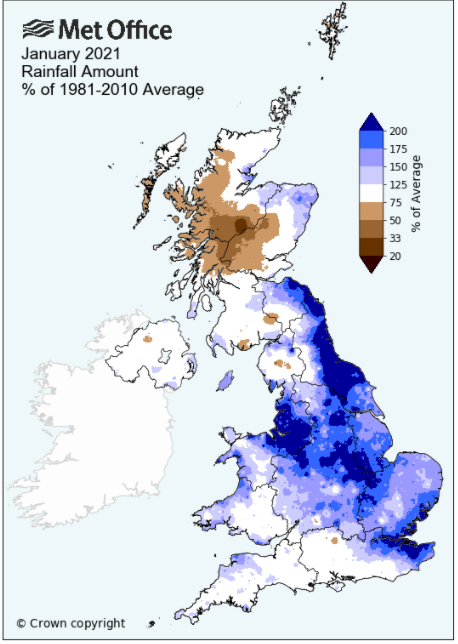
A cold wintry month - but also wet at times
Whilst not exceptional in any way, January actually had the feel of winter about it - snow fell and lay on the ground on an above average number of days, likewise the number of frosts, some of which were very keen and for the first time since 2014 no day managed to attain 10°c. However, whilst rainfall finished below average it was still wet at times with a couple of heavy daily falls.
With high pressure in charge the month began relatively dry, but more notably cold and frosty. Air frosts were recorded every night bar one up to the 16th and included several that were colder than anything recorded in the whole of 2020.
After the cold start it then became unsettled and slightly milder with 'Storm Christoph' (19th - 21st) bringing a wet spell of weather, although Cumbria tended to avoided the worst of the conditions.
The 23rd - 26th were dry and cold, with a brief unsettled spell 26-28th before the month finished dry and cloudy with a cool easterly wind.
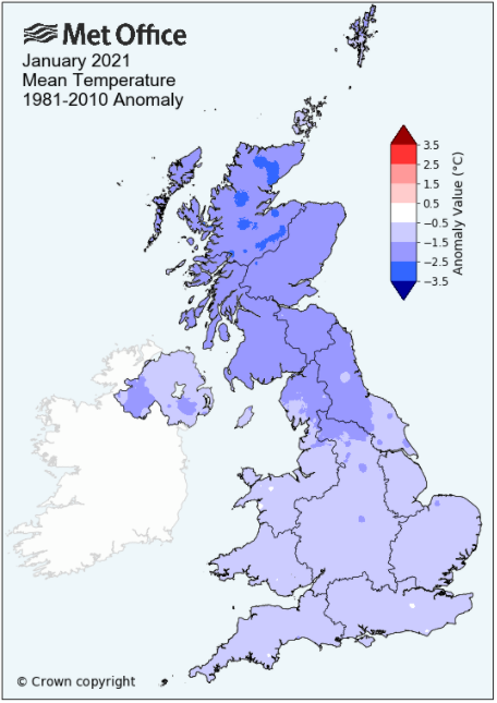
MSLP of 1010.4 Mb was -1.7 MB below the local average for the month and overall a mean minimum of -1.66°c and a mean maximum of 4.44°c saw the temperature 1.96°c below the twelve year average for this site.
It was the coldest since 2010 and of the thirteen now recorded, 11 have been warmer and one has been colder - the highest maximum temperature recorded being 9.6°c (11th), the lowest minimum -9.2°c (9th).
Rainfall of 129.7 mm (Maulds Meaburn North 127.1 mm -- Castlehowe Scar 141.0 mm) was 92.2% of average for 2008-20 and made it the driest January since 2019. Of the fourteen now recorded, 8 have been wetter and 5 have been drier.
During the month the following was recorded: snow fell on 14 days (2nd-9th, 14th, 16th, 20th-21st, 26th and 28th), 6 days of 'Lying Snow' (8-10th, 14-16th) and fog on 4 days (7th, 14th, 19-20th). The wind speed averaged 5.16 mph, with a maximum gust of 36 mph (3rd).
At the Met' Office site at Newton Rigg a mean temperature of 1.57°c is 1.73°c colder than average and is the coldest since 2010. In a series back to 1952, 9 have been colder and 60 have been warmer.
Rainfall totalled 125.4 mm (123.5% of average), making it the wettest since 2015. Since 1900 when the record began, 28 have been wetter and 93 have been drier.
At Appleby in Westmorland a total of 112.7 mm represented 120.9% of its average (1857-2020) and made it the wettest since 2016 - in a record that commenced in 1857, 57 have been wetter and 107 drier. Rainfall totals across Cumbria were somewhat mixed, being either side of average. This saw Brothers Water down at 82.7% of its average and other parts of the LDNP also below average, but one small corner of NE Cumbria saw an excessive above average total. This saw Kirby Thore at 146.9% of its average, but further north at Haresceugh Castle a daily fall of 66.3 mm on the 27th saw the final percentage pushed up to 216%.
Figures from the Environment Agency�s rainfall sites were, (figure in brackets being the monthly average for 1961-90) �Data kindly provided by the Hydrometry and Telemetry team of the Environment Agency (Penrith)�:
Kirkby Thore 103.0 mm (70.1 mm)
Haresceugh Castle (Kirkoswald) 198.03 mm (91.7 mm)
Brothers Water 229.19 mm (277 mm)
Orton (Shallowford) 187.4 mm (186.8 mm [average for 1967-2019])
366.2 mm at Seathwaite Farm (Borrowdale - 372 mm [average for 1981-2010]) - making it the driest since 2019 and in a record that commenced in 1845 90 have been drier and 86 wetter.
.
General Synoptic Report for the Month
High pressure (HP) was the dominant feature at the start of the month, through to the 10th which resulted in cold and wintry conditions. Initially the HP was in the Atlantic then with a new system ridging down from Norway it ensured a NW-NE'ly airflow and with the occasional trough or frontal system moving over the UK we also saw some snow.
From the 1st to the 16th only the 11th avoided an air frost and in the same period snow fell every day of 2nd - 9th and then on the 14th and 16th, by the end of which the mean temperature for the month was below freezing. Both the 2nd and 3rd saw the temperature drop below -5°c, this being colder than anything from 2020. There was the occasional flake of snow, but through this period rain/snowfall was patchy and light, the first ten days only recording 6.0 mm of rain.
The 7th was chilly with a maximum of just 0.6°c and saw light snow all day as a cold front from the NW pushed south. The snow was only light and patchy, but became heavier overnight into the 8th to leave a covering of 2.5cms which, with further snow during the day, had become 3cms on the 9th. The 8th was again chilly and like the 7th only peaked at 0.6°c (even colder at Newton Rigg with a maximum of -0.3°c where an 'Ice Day' was recorded) and then behind that cold front, HP in the Atlantic re-asserted itself and the night became cold and clear with the temperature plummeting to -9.2°c (15.4°f) this being the coldest night for several years.
Despite a slight thaw, snow had laid on the ground for the three days of 8-10th, this being as many as the whole of 2020! The days were typically cloudy around this period and gave a grey day with light rain on the 11th as the flow now backed SW'ly. That SW'ly flow also saw the temperature perk up to a month's high of 9.6°c (49.3°f). However, up to this point, every day all apart from the 10th, had seen the maximum temperature remain below 5°c.
The 13th would be a grim day as a frontal system from the SW approached the UK and became static over the northern part of England. Rain fell steadily from mid morning through into the 14th to give 24.9 mm. However, at 0630 Hrs on the 14th the rain turned to snow and by 0900 Hrs there was a cover of 2cms. The front that had brought this rain and snow was slow to clear and more snow fell during the day to leave a cover 4cm deep on the 15th.
Lying snow had been recorded on the three days of 14-16th, but now it would turn unsettled and that bit milder. Each day of the 16-19th all saw rain overnight, but with the 16-17th staying dry through the rest of the day, the 18th having long spells of drizzle - then 'Storm Christoph' arrived and held sway during the 19th - 21st.
Whilst it was wet over Cumbria, we tended to avoid the worst. Its passage was from the SW, becoming slow and stationery over the northern part of England before pivoting and moving away NE and introducing a northerly flow as it did so. After that drizzle on the 18th the 19th was just wet and foggy and the rain did not abate, continuing all day 20th before turning to snow late in the day as that N'ly flow was introduced. The 19th saw 27.5 mm of rain with a further 19.3 mm 20th, but overnight into the 20th the snow steadily became sleety and then died out to leave just a faint and broken cover come the morning.
Other 09-0900GMT falls on the 19th included: Honister Pass 132.8 mm -- Seathwaite Farm 108.4 mm -- Brothers Water 70.9 mm -- Orton 53.2 mm -- Kirby Thore 19.4 mm
Behind the fronts the 21st was an improving picture with sunny spells developing in the afternoon. Whilst the UK now sat in a nominal area of low pressure (LP), the gradient became slack and weak. We tended to avoid any fronts and subsequently we enjoyed further spells of sun through to 25th, but with cooler day-time temperatures and overnight frosts 23rd - 26th, falling to -5.1 on the 25th.
The 26-29th saw the return of unsettled conditions as a series of fronts from the Atlantic pushed across the UK. The 26th saw drizzle and/or light rain and with a little snow in the afternoon. With a temporary slack pressure gradient following on behind these fronts the 27th stayed dry and managed to feel mild at 7.9°c.
Several areas of LP out in the Atlantic now pushed more fronts towards the UK from the SW overnight into the 28th bringing a spell of heavy rain (20.6 mm) and which included a spell of sleety snow. Fronts remained near or over the northern part of England and the rest of the 28th and 29th were all rather grey and drizzly and whilst rainfall amounts were light it had a rather gloomy feel.
The month ended with a north-south border to our weather, colder air just to our north and warmer, moist air to the south with a new area of LP moving across southern England. Combined with the pressure gradient slackening over the northern half of the UK an ESE-ENE'ly flow was introduced and whilst the final two days were dry, they were cloudy and cold, clear skies overnight into the 31st allowing the temperature to fall to -4.8°c.
Rainfall totalled 129.7 mm for the month, with rain recorded on 21 days of which 15 were 'Wet days' (1.0mm +).
The Mean Temperature for the month was 1.39°c -- The Mean Max' was 4.44°c -- The Mean Min' -1.66°c.
We had 20 Air Frosts in the month (year 20) -- Grass Frosts totalled 24 (year 24).
The 1 foot soil temp ranged from a low of 2.0°c on the 26-27th to a high of 4.7°c on the 20th -- with a monthly mean of 3.0°c
The 1 meter soil temp ranged from a low of 5.0°c on the 28-30th to a high of 6.5°c on the 1st -- with a monthly mean of 5.6°c
JANUARY 2010
FEBRUARY 2010
MARCH 2010
APRIL 2010
MAY 2010
JUNE 2010
JULY 2010
AUGUST 2010
SEPTEMBER 2010
OCTOBER 2010
NOVEMBER 2010
DECEMBER 2010
JANUARY 2011
FEBRUARY 2011
MARCH 2011
APRIL 2011
MAY 2011
JUNE 2011
JULY 2011
AUGUST 2011
SEPTEMBER 2011
OCTOBER 2011
NOVEMBER 2011
DECEMBER 2011
JANUARY 2012
FEBRUARY 2012
MARCH 2012
APRIL 2012
MAY 2012
JUNE 2012
JULY 2012
AUGUST 2012
SEPTEMBER 2012
OCTOBER 2012
NOVEMBER 2012
DECEMBER 2012
SUMMER 2012
REVIEW OF 2012
JANUARY 2013
FEBRUARY 2013
MARCH 2013
APRIL 2013
MAY 2013
JUNE 2013
JULY 2013
AUGUST 2013
SEPTEMBER 2013
OCTOBER 2013
NOVEMBER 2013
DECEMBER 2013
REVIEW OF 2013
JANUARY 2014
FEBRUARY 2014
MARCH 2014
APRIL 2014
MAY 2014
JUNE 2014
JULY 2014
AUGUST 2014
SEPTEMBER 2014
OCTOBER 2014
NOVEMBER 2014
DECEMBER 2014
WINTER 2014
REVIEW OF 2014
JANUARY 2015
FEBRUARY 2015
MARCH 2015
APRIL 2015
MAY 2015
JUNE 2015
JULY 2015
AUGUST 2015
SEPTEMBER 2015
OCTOBER 2015
NOVEMBER 2015
DECEMBER 2015
REVIEW OF 2015
JANUARY 2016
FEBRUARY 2016
MARCH 2016
APRIL 2016
MAY 2016
JUNE 2016
JULY 2016
AUGUST 2016
SEPTEMBER 2016
OCTOBER 2016
NOVEMBER 2016
DECEMBER 2016
REVIEW OF 2016
JANUARY 2017
FEBRUARY 2017
MARCH 2017
APRIL 2017
MAY 2017
JUNE 2017
JULY 2017
AUGUST 2017
SEPTEMBER 2017
OCTOBER 2017
NOVEMBER 2017
DECEMBER 2017
REVIEW OF 2017
JANUARY 2018
FEBRUARY 2018
MARCH 2018
APRIL 2018
MAY 2018
JUNE 2018
JULY 2018
AUGUST 2018
SEPTEMBER 2018
OCTOBER 2018
NOVEMBER 2018
DECEMBER 2018
REVIEW OF 2018
JANUARY 2019
FEBRUARY 2019
MARCH 2019
APRIL 2019
MAY 2019
JUNE 2019
JULY 2019
AUGUST 2019
SEPTEMBER 2019
OCTOBER 2019
NOVEMBER 2019
DECEMBER 2019
REVIEW OF 2019
JANUARY 2020
FEBRUARY 2020
MARCH 2020
APRIL 2020
MAY 2020
JUNE 2020
JULY 2020
AUGUST 2020
SEPTEMBER 2020
OCTOBER 2020
NOVEMBER 2020
DECEMBER 2020
REVIEW OF 2020
OTHER ARTICLES
The Oldest Inhabitant
An Inch Of Scotch Mist
But it's meant to be Summer (Summer 2017)
© Darren Rogers 2010-20
Want to comment on this site? email